Tocht Auto Boyle Municipal District - j06_2 - Photo
 DUPORT16
DUPORT16

Gebruiker

© OpenStreetMap contributors
Lengte
Lengte
69 km
Max. hoogte
Max. hoogte
90 m
Positief hoogteverschil
433 m
Km-Effort
Km-Effort  
74 km
Min. hoogte
Min. hoogte
34 m
Negatief hoogteverschil
441 m
Boucle
Boucle
Neen
Datum van aanmaak :
2023-05-29 11:22:22.981
Laatste wijziging :
2023-05-29 12:33:24.16

(0 Bericht)

Auto
Auto
1h10
Moeilijkheid : Heel gemakkelijk

Scan deze QR-code om de tocht te openen in de SityTrail-applicatie

Gratisgps-wandelapplicatie

Logo SityTrail SityTrail

IGN / Geografische instituten

SityTrail uit de App Store downloaden SityTrail uit Google Play downloaden

Logo SityTrail SityTrail World

De wereld gaat voor u open

SityTrail uit de App Store downloaden SityTrail uit Google Play downloaden SityTrail op Huawei AppGallery downloaden

Over ons

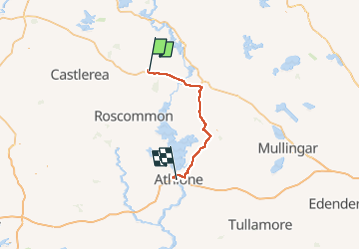
Tocht Auto van 69 km beschikbaar op Onbekend, County Roscommon, Boyle Municipal District. Deze tocht wordt voorgesteld door DUPORT16.

Hoogteprofiel

Plaatsbepaling

Land:
Ireland
Regio :
Onbekend
Departement/Provincie :
County Roscommon
Gemeente :
Boyle Municipal District
Locatie:
Strokestown ED
Vertrek:(Dec)
Vertrek:(UTM)
559407 ; 5958986 (29U) N.

Wandeltochten in de omgeving


Sluiten
Mijn abonnementen